We recently added a copy of the 1900 Rice County plat map book to the Northfield History Collaborative, and I couldn’t be more excited. I love maps!
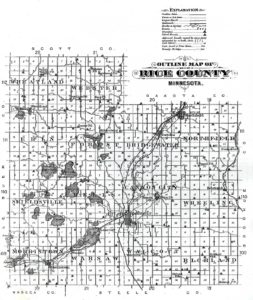
Outline map of Rice County, 1900. Page 3 of the Plat Book of Rice County, Minnesota.
A plat map shows the divisions of a piece of land in a township, city, and rural areas. It features natural and civic landmarks, like rivers and schools, but it also shows the borders of each piece of land, whether it is a small lot in the village or a large farm in the countryside. And it identifies the name of the owner of the land, as well. This book includes maps of each of the county’s townships, from Bridgewater to Wheeling, as well as its cities and towns – Dundas, Nerstrand, Northfield, and more.
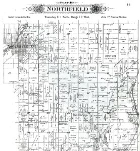
Selection of the plat map of Northfield Township, 1900. Page 13 of the Plat Book of Rice County, Minnesota.
Many of the names of land owners are the same, which makes me wonder if they are all part of the same extended family, or if they came from the same town or village back East (or across the globe). And some owners are clearly women, which for 1900 is an interesting fact – what circumstances allowed them to be listed as a landowner at that time? For those of you who like tracking demographics, especially where people came from, there are some clues in the names as well – you have some clearly Scandinavian-heritage surnames like Engeseth alongside a Germanic Koester and Blau, next to a Keegan and Pritchard and Drentlaw (and even an O’Brien or two).
We also have a 1915 book of plat maps for the county. When you compare the maps, what is the same? What is different?
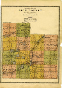
Outline Map of Rice County, 1915. Page 3 of the Atlas and Farmers’ Directory of Rice County Minnesota 1915.
While maps provide many answers, they also lead to new research questions. We hope you enjoy looking through the townships and villages of our county more than 100 years ago.
For more plat maps from the whole state of Minnesota, visit the State of Minnesota’s Public Land Survey System website, the Michael Fox Map Collection of the Minnesota Historical Society online, and the John R. Borchert Map Library of the University of Minnesota Libraries.